top of page

01- A
FILM SERIES +
EVENT GRAPHICS
In partnership with Katra Film Series, brand identity for a new film series was developed.
01- A
FILM SERIES +
EVENT GRAPHICS
In partnership with Katra Film Series, brand identity for a new film series was developed.
01- A
FILM SERIES +
EVENT GRAPHICS
In partnership with Katra Film Series, brand identity for a new film series was developed.
BOSTON
SHORELINES
DIGITAL + ENVIRONMENTAL DISPLAY
03 - A
MUSEUM EXHIBIT & RESEARCH SPRINT
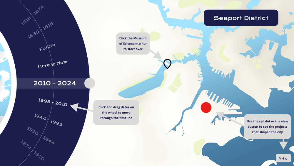
In partnership with Berkman Klein Center for Internet & Society at Harvard University and the Boston Museum of Science, I created digital environmental graphic displays for the Museum of Science special exhibits and "Rise Up" Weekend series of events. This display told the story of changing shorelines of the city of Boston from 1619 until now for the Museum of Science audience.


BERKMAN KLEIN
CENTER @
HARVARD UNIVERSITY
The BKC Research Sprint program brings together experts and emerging scholars. These educational sprints are an collaboration between academics, practitioners, and public-sector partners. Over eight to ten weeks, participants co-create outputs like aimed at educating the public on pressing topics and policy perspectives.
BROWN UNIVERISTY
& RHODE ISLAND SCHOOL OF DESIGN
Immersed in Boston's public data hub, Analyze Boston. Interactive data visualizations exploring urban life, from the city's coastline changes to insights into its tree population were created. Showcased at the Museum of Science, this project offered new perspectives on data generation and explored Boston.
CITY OF BOSTON
MUSEUM OF
SCIENCE
In 2024, the Museum of Science dedicated its efforts to the "Year of Our Earthshot," focusing on climate solutions for sustainable living. These data visualizations spotlighting urban environments' beauty and vulnerability, emphasize the role of data in promoting a more sustainable and equitable future.

PHOTO CREDIT: BOB O'CONNER + HARVARD LAW SCHOOL
03 - B
RESEARCH SPRINT
The Berkman Klein Center, in collaboration with the Edgelands Institute and the MADE program at Brown University and RISD, organized a research sprint culminating in a museum exhibit showcasing innovative urban data visualizations in Boston. Partnering with the Museum of Science, Boston, the exhibit debuted in April 2024. Over eight weeks, 22 students from Harvard and MADE explored data's potential to enhance urban life while addressing ethical concerns. Their work highlights global implications for urban data use, focusing on AI policy, surveillance, and data ethics in cities.


CITY OF BOSTON
OPEN SOURCE
DATA INITATIVE
Analyze Boston's public data hub offers a wealth of diverse information spanning transportation, public health, education, demographics, and more. This resource supports research, informs policymaking, and fosters innovation by providing transparent and accessible data for analysis. While empowering informed decision-making and promoting collaboration across sectors, considerations such as data privacy and ethical use remain crucial in leveraging this valuable asset effectively for the benefit of Boston's residents and stakeholders.
MASSACHUSETTS INSTITUTE OF TECHNOLOGY PRESS
The Massachusetts Institute of Technology (MIT) Press's book "Mapping Boston" offers a compelling exploration of Boston's evolving shoreline and its impact on the city's development. The book employs historical maps, aerial imagery, and geographic data to illustrate how Boston's waterfront has changed over time. It examines how land reclamation projects, infrastructure development, and environmental changes have shaped the city's coastal areas and influenced urban planning decisions.
NATIONAL OCEANIC & ATOMOSPHERIC ADMINISTRATION
The National Oceanic and Atmospheric Administration's (NOAA) open data resources played a crucial role in developing an interactive museum exhibit about Boston's changing shorelines over time. These resources provided historical and current data on sea levels, coastal erosion, and other environmental factors that have shaped Boston's waterfront. The relationship between urban development and environmental change via NOAA data about costal development was shown.

03 - C
MUSEUM EXHIBIT
The Museum of Science exhibit on Boston's changing shorelines uses interactive displays and historical data to explore how natural and human factors have shaped the city's coastal evolution. It educates visitors on coastal geology, environmental science, and urban planning while highlighting the impact of sea level rise and climate change. The exhibit engages visitors with interactive maps and technological insights, fostering awareness and discussion on sustainability and coastal resilience.

DESKTOP WEBSITE
%20_Seaport_%20-%20MOS%20Screen%2075_%20-%20%201.png)

%20_The%20Big%20Dig_%20-MOS%20Screen%2075_%20-%20%201.png)
%20-_Faneuil%20Hall_%20-%20MOS%20Screen%2075_%20-%20%201.png)

%20-_Backbay%20Basin_%20-%20MOS%20Screen%2075_%20-%201.png)

%20-_Backbay%20Basin_%20-%20MOS%20Screen%2075_%20-%202.png)
%20-%20_North%20Station_%20-%20MOS%20Screen%2075_%20-%20%201.png)
%20-_North%20Station%20-%20MOS%20Screen%2075_%20-%20%202.png)
IN-MUSEUM TOUCH-SCREEN DISPLAY


IN-MUSEUM WALL-MOUNTED DISPLAY

VIDEO
03 - D
"RISE UP" WEEKEND +
"YEAR OF OUR EARTHSHOT"
The Museum is in the midst of its “Year of Our Earthshot,” a yearlong exploration of the climate solutions that will help us all live more sustainably. "The Museum of Science is spending the entirety of 2024 shining a light on the climate solutions that are transforming the ways we live, move, eat, and work and the innovators who are making these transformations happen," said David Sittenfeld, director of the Museum's Center for the Environment. "The work ... shines a light on the beauty and fragility of our urban environments and underscores the importance of leveraging data visualization to promote a more sustainable and equitable future for all.”


ONLINE ARTICLES


bottom of page